Outdoor guide
Walking and hiking near Granada
Bosque Alhambra forest loops, the Cerro del Sol ridge, Sacromonte cave trails, and Sierra Nevada day hikes — all accessible from the city centre.

Written by
James Walker Seven years resident in Granada. Specialist in Nasrid architecture, Al-Andalus history, and Andalusian walking routes.
Published
Updated
Granada sits at 738 metres above sea level, with the Sierra Nevada rising immediately behind it to over 3,000 metres. This geography means serious hiking is not a day-trip logistics problem — it is a bus ride. The forest above the Alhambra starts at the edge of the palace complex. The cave trails above Sacromonte begin five minutes from the city centre. You do not need a car for most of what is listed here.
The range of difficulty is also unusually wide. On the same morning you could walk a shaded forest loop in trainers, or take a bus to the base of Mulhacén and start a route that gains 1,200 metres. This guide covers the accessible options first — the walks and trails that do not require specialist gear or fitness — and then goes further afield for those who want to push harder.
Easy: Bosque Alhambra forest walk
Easy 4.1 miles / 6.6 km 1.5–2.5 hours
The Dehesa del Generalife — usually called the Bosque Alhambra — is a 40-hectare Mediterranean forest above and around the Alhambra complex. Holm oak, Scots pine, and cypress on gently rolling terrain, with the palace walls appearing between the trees on the upper sections. It is Granada's closest thing to a city park, used by residents for morning runs and Sunday walks.
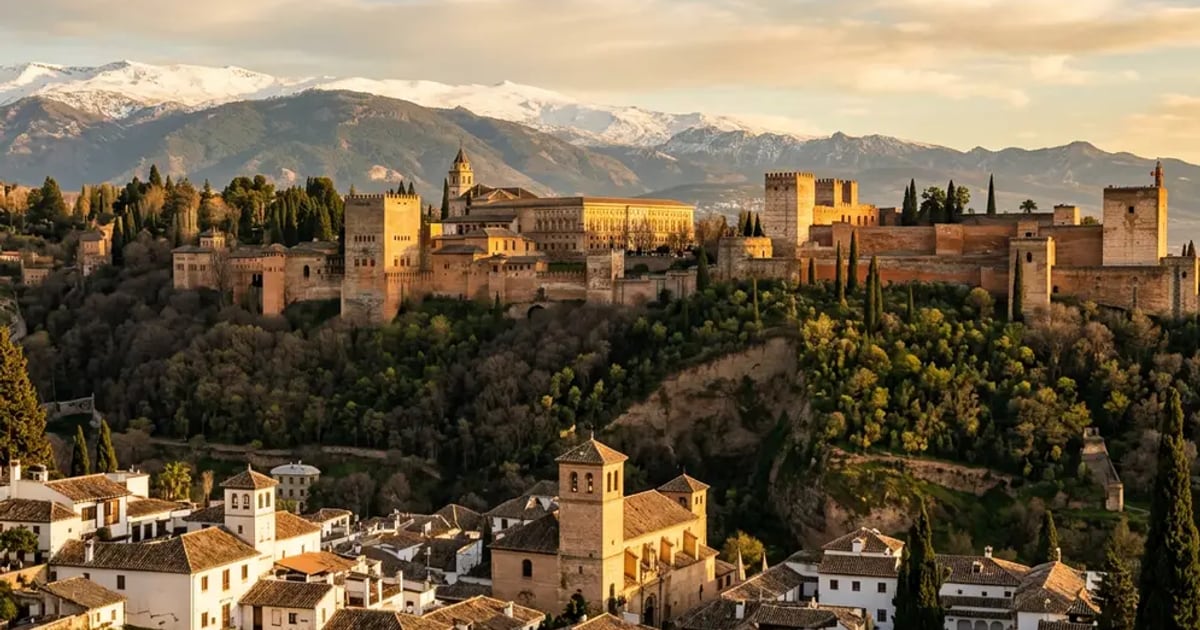
The main loop climbs from the Cuesta del Rey Chico gate to the Silla del Moro viewpoint — a ruined Nasrid watchtower above the palace — and returns via the forest road. The Silla del Moro sits at roughly 800 metres, 60 metres above the Alhambra towers, and the views of the palace complex against the Sierra Nevada are among the least-crowded panoramas in Granada. Most visitors at the Alhambra never think to continue uphill into the forest; you will often have the viewpoint entirely to yourself.
Access is free. No ticket needed for the forest section; the Alhambra ticket covers the palace only. Trailhead: walk up the Cuesta del Rey Chico from the Realejo neighbourhood, or exit the Alhambra complex via the forest path after your palace visit.
Moderate: Cerro del Sol
Moderate ~14 km return 1.5–2 hours to summit 600–700 m elevation gain
The Cerro del Sol is the ridge directly above the Alhambra to the south-east, accessible from Monachil village 14 kilometres from the city centre. The trail climbs steadily through limestone terrain to a summit with unobstructed views down the Darro valley, across the city, and — on clear days — to the coast. The Alhambra appears almost directly below.
The route from Monachil takes 1.5 to 2 hours at a steady pace, with a sustained climb over the first section and flatter walking near the ridge. The stone is pale limestone that reflects heat in summer, so the timing advice in the Insider Tips section below applies. In April and May the slopes carry wildflowers — rockrose, lavender, thyme — and the ridge itself is breezy regardless of temperature in the valley.
The trail also connects downward toward the Darro gorge, linking with the river path back to the city. This makes a one-way descent possible if you arrange a bus to Monachil and walk back to Granada through the gorge: a satisfying 15-kilometre day.
Moderate: Sacromonte trails
Moderate ~8 km circuit 2.5–3 hours 280 m elevation gain
Above the Sacromonte cave neighbourhood, a network of tracks climbs through terraced hillsides and scrubland toward the Sacromonte Abbey (Abadía del Sacromonte, founded 1600). The main circuit — starting from the upper Sacromonte road and returning via the ridge — passes the cave dwellings from above, giving a different perspective on the whitewashed facades and vegetable gardens cut into the hillside.
The views from the ridge take in the Alhambra, the Albaicín below it, and the plain of Granada to the south. In early morning, before the heat and haze build, you can see the Sierra Nevada snowline from here even in May. The descent toward the Generalife gardens is well-marked and connects with the Bosque Alhambra circuit if you want to extend the walk.
Start from the upper Sacromonte road (Camino del Sacromonte) or from the Albaicín via the Cuesta del Chapiz. The trail is largely unsignposted — download the route on AllTrails before you leave. Hiking boots recommended; some sections of loose stone.
Day hike: Sierra Nevada
Challenging Varies by route Full day from Granada 2,000–3,400 m altitude
The Sierra Nevada National Park starts 50 minutes from Granada by bus or car. The two most accessible peaks are Pico del Veleta (3,394 m) and Mulhacén (3,479 m, the highest point in mainland Spain). Both are reachable as day hikes in summer from the Hoya de la Mora car park (2,500 m), which the Bonal bus serves from Granada.
The Veleta route from Hoya de la Mora involves roughly 900 metres of ascent on a well-marked path; the full day (summit and return) takes 6–8 hours including breaks. Mulhacén adds distance and involves a traverse along the ridge — allow 8–10 hours. Both routes cross high exposed terrain above the tree line. Weather changes fast at altitude: even in July, temperatures on the ridge can drop 15–20°C below the city. Layers and waterproofs are essential regardless of the morning forecast in Granada.
Altitude caution
The Sierra Nevada high trails start above 2,500 metres — altitude that affects some visitors even without exertion. If you arrive from sea level, give yourself a day in Granada before heading to the summit trails. Stay hydrated, descend if you feel dizzy or headached, and do not underestimate how quickly conditions change above the treeline.
For a shorter and more accessible Sierra Nevada experience, see the full Sierra Nevada guide, which covers the cable car, the ski area, and day-trip options with and without your own transport.
Advanced: Los Cahorros de Monachil
Advanced ~10 km circuit 4–5 hours Hanging bridges and scrambling
Los Cahorros is a gorge trail along the Monachil River, starting from Monachil village and following the river through a narrow limestone canyon. The route crosses four hanging bridges — swinging wire constructions suspended above the gorge — and involves sections of via ferrata-style scrambling along irrigation channels cut into the canyon walls. It is the most technically demanding walk in this guide.
The gorge is spectacular: cream-coloured limestone, clear water, and the constant sound of the river echoing off the walls. In spring the stream runs high from snowmelt and the bridges are at their most dramatic. In summer the water level drops and some crossings become wading sections rather than bridges. Autumn is probably the most comfortable season — cooler, drier, with autumnal colour on the scrub above the gorge.
Sturdy hiking boots with ankle support are essential; trainers are not adequate for the via ferrata sections. The route requires no specialist equipment beyond boots and a head for heights on the bridges. Trailhead: Monachil village, reached by bus from Granada bus station. Parking available if driving.
If Los Cahorros has whetted your appetite for technical outdoor pursuits, the Granada outdoor adventures guide covers paragliding at Cenes de la Vega, rock climbing at Los Cahorros, and via ferrata and canyoning options within easy reach of the city.
Practical tips
Getting there
Bosque Alhambra: walk from Realejo or exit Alhambra complex. Sacromonte trails: bus C34 from Plaza Nueva. Cerro del Sol / Los Cahorros: bus to Monachil from Granada bus station. Sierra Nevada: Bonal bus from Granada bus station (summer only for high trails).
Best seasons
Spring (April–May): wildflowers, mild temperatures, snowline still visible. Autumn (September–October): clear skies, comfortable heat, fewer tourists. Summer: city walks early only; Sierra Nevada high trails accessible but exposed. Winter: city walks pleasant; Sierra Nevada may require snowshoes.
What to pack
Hiking boots for anything beyond the Bosque Alhambra. Sun protection year-round — the exposed limestone reflects heat. 2–3 litres of water per person; no reliable sources on trail. Layers for altitude (temperature drops 10°C per 1,000 m). Downloaded map or AllTrails route for Sacromonte and Cerro del Sol.
Guided options
Sierra y Sol offer professional guided hiking tours from Granada, including the Sierra Nevada and Alpujarras villages. Las Alpujarras is the other major hiking destination within a day's reach — white villages, terraced hillsides, and Trevélez (Spain's highest village).
Frequently asked questions
Frequently asked questions
What is the easiest walk near Granada for non-hikers?
The Bosque Alhambra (Dehesa del Generalife) is the most accessible option: a 4-mile forest loop on well-maintained paths through Mediterranean woodland, with views of the Alhambra and the Sierra Nevada. No steep scrambling, no technical terrain, and you reach the trailhead by walking up from the city. The Darro riverside walk from Plaza Nueva through the Carrera del Darro is even flatter — essentially a paved promenade — and makes a good warm-up or standalone option.
Can I hike in the Sierra Nevada without a car?
Yes. The Autocares Bonal bus runs from Granada bus station to Pradollano (Sierra Nevada ski resort) and on to Hoya de la Mora in summer. From Hoya de la Mora you can access the high trails without your own transport. The journey takes around 45–50 minutes. Check current timetables with Granada's tourism office before your visit, as schedules vary by season. Sierra Nevada full guide.
When is the best time to hike near Granada?
April to May and September to October are the sweet spots: mild temperatures (14–22°C), wildflowers in spring, clear skies in autumn. Avoid July and August for anything beyond a short early-morning walk — the heat is real (35–40°C) and the exposed ridges above the city have no shelter. Winter walking at city level is pleasant and uncrowded; Sierra Nevada high trails may be snow-covered from December through March.
How difficult are the Sacromonte trails?
The main Albaicín–Sacromonte circuit is moderate: about 5 miles with 280 metres of elevation gain, taking 2.5–3 hours at a relaxed pace. The surface is a mix of paved track, dirt path, and occasional loose stone. Hiking boots are recommended over trainers. The trails pass through the cave neighbourhood and connect to viewpoints above the city — the views of the Alhambra from the Sacromonte ridge are among the best in Granada.
Is the Cerro del Sol walk suitable for families?
Moderate suitability. The Cerro del Sol trail from Monachil village involves around 600 metres of elevation gain over 14 kilometres, which is manageable for older children (10+) who are used to walking. Younger children will find it long and exposed. A better family option is the Bosque Alhambra loop, which is shorter, shadier, and returns you to the Alhambra complex without a bus journey back.